Current priorities / Houston land transfer to AIDEA
6,800 acres north of Houston, and access is still not in writing.
If you hunt, trap, mush, ride or cut firewood off Zero Lake Road, on the Houston-Willow Creek Trail, around Bench Lake or north of the Little Susitna, this is your country.
The state calls it a noncompetitive sale to a public and charitable use applicant, ADL 234762, with an amendment to the Southeast Susitna Area Plan, Land Classification Order SC-08-001A04 and Mineral Order 1330. Most people just call it the AIDEA land transfer.
On 10 November 2026 the Commissioner of Natural Resources approved giving about 6,800 acres of state land, two miles north of Houston, to the Alaska Industrial Development and Export Authority at no cost, for a "multi-use industrial and energy development district." It started at nearly 20,000 acres. Alaskans pushed back, and the state listened in part. The part it did not listen to is the part that matters most for access. And the trail network DNR points to as protected is held only by a five-year interim authorization that expires in 2031.
What was approved
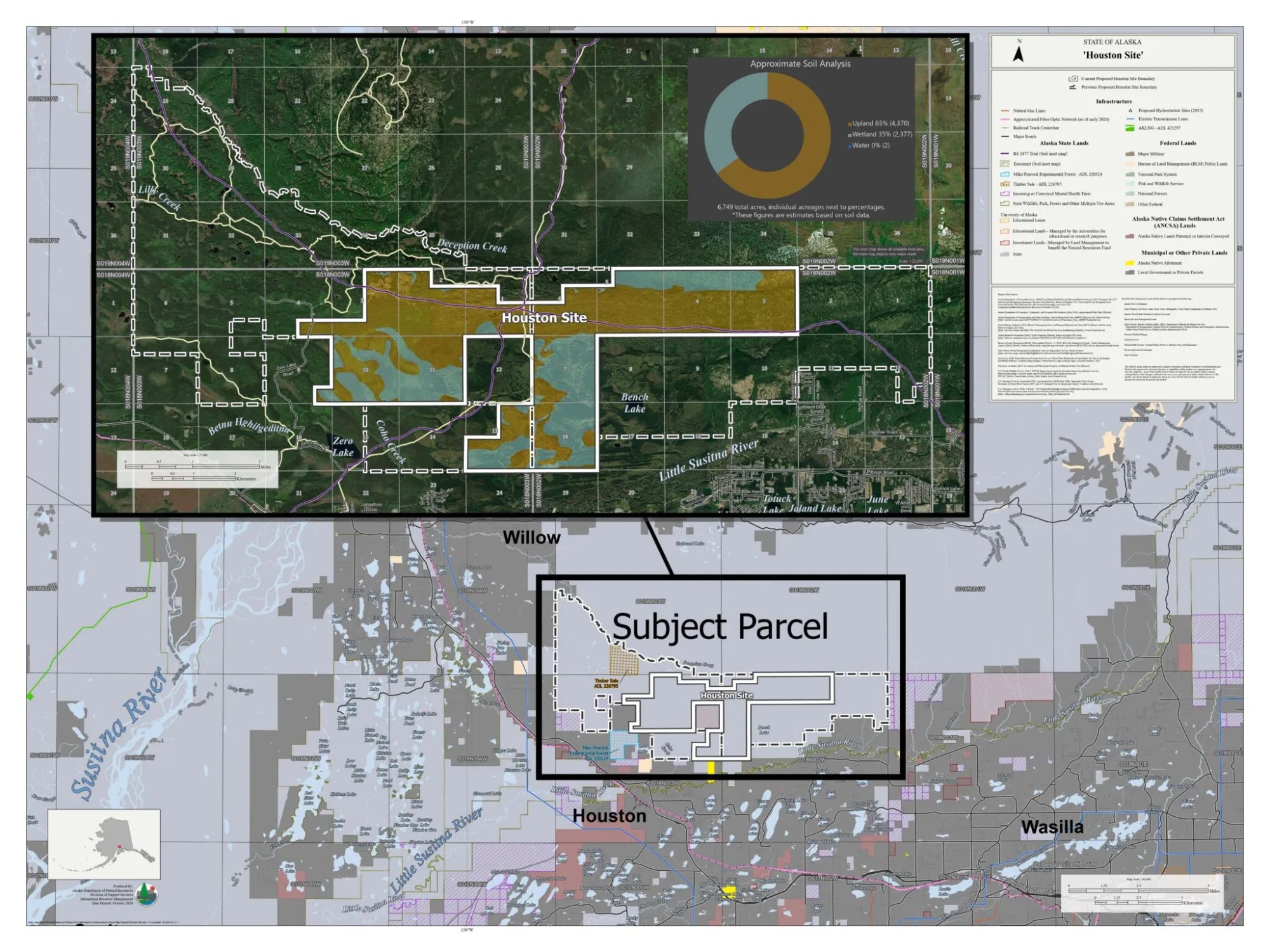
The Final Finding and Decision conveys roughly 6,800 acres in Township 18 North, Ranges 2 and 3 West, Seward Meridian, in two pieces DNR calls the Houston West and Houston East sites. The southern edge sits about half a mile north of the Little Susitna River. Zero Lake Road, off the Parks Highway just north of milepost 59, is the way in.
Three related orders were signed the same day. About 6,150 acres that were classified as Forest, Wildlife Habitat and Water Resources land are now reclassified as Settlement land in a new area plan unit, H-33, whose only stated purpose is "disposal in association with ADL 234762." The whole parcel is closed to new mineral entry. The state receives nothing for the land.
The stated purpose is "creating jobs, improving energy reliability, and diversifying the economy." No tenant, project or footprint has been named. DNR's own summary of comments acknowledges "the prospect of scalable data center facilities."
The transfer is also now being challenged in court. The Mat-Su Sentinel reports on a lawsuit arguing that the Houston-area land transfer violates the Alaska Constitution.
 Open full size
What Alaskans won
More than 2,300 people commented. So did the Alaska Outdoor Council, the Alaska Snowmachine Alliance, the Meadow Lakes Community Council, the Wasilla Soil and Water Conservation District, the Senate Resources Committee, and AOAA. It made a difference, and it is worth saying so plainly.
Two thirds of the land stays public.
The transfer was cut from nearly 20,000 acres to about 6,800. DNR says the remaining 12,700 acres stay under state management under the existing area plan.
The state kept its right to take the land back.
DNR had proposed waiving the reversionary interest under AS 38.05.810(g). Every one of the letters on this page objected. The final decision keeps it: land AIDEA does not develop as its plan describes is supposed to revert to the state.
A ten year clock.
AIDEA has ten years to survey the land and finish the pre-patent requirements. If it does not, the approval ends and the land goes back to general state management.
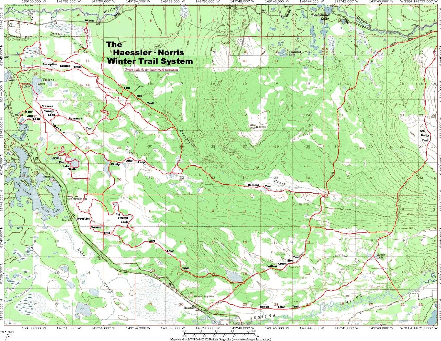
The Haessler-Norris trails are out.
The boundary was redrawn so it no longer overlaps the Haessler-Norris trail system, and so that it crosses public access easement ADL 52374-A only once. That keeps those trails on state land. As the next section explains, it does not make them permanent.
The RS 2477 trails are confirmed.
The state's own access unit says the validity of RST 95, the Houston-Willow Creek Trail, and RST 1691, the Herning Trail-Question Creek, "is not in question," with a corridor at least 100 feet wide. Section line easements, 50 feet each side, are reserved.
 Open full size
What is still missing
Our letter asked for one thing above all: that continued public use of the land not actually needed for development be protected in specific, enforceable language in the recorded conveyance, before title changes hands. The decision does not do that.
-
The trails DNR steered around are held by a five-year interim permit.
DNR's main answer on access is that it moved the boundary off the Haessler-Norris trail system. But the public easement for that system, held under case ADL 230260, with the Mat-Su Borough as the applicant, has never been finished. The state's own case record shows its status as "interim authorization."
A five-year entry authorization was first issued in February 2019 to let the trails be surveyed. It was due to expire in February 2024. On 11 September 2026 it was reissued for another five years, and it now expires 11 September 2031. Only if the survey and other conditions are completed does the public get an easement: 50 feet wide, about 51 miles long, and even then for a 25-year term, not forever. The same case covers the northern part of Zero Lake Road.
Eighteen years after the case was opened in 2008, the trails people use most around this transfer are still held by a temporary permit. Next to a new industrial district, that is not good enough.
There is a second problem. The trail authorization covers state land in Sections 1, 2, 3 and 4 of Township 18 North, Range 3 West, and the case's land records also list Section 13. The land being given to AIDEA includes parts of every one of those sections. DNR says it drew the line to avoid the trails, but the trails have never been surveyed, so there is no surveyed line to show that it does. That should be settled on the ground, and the easement finished, before any patent issues.
-
A trail through restricted land is not a trail through public land.
The decision protects corridors: RS 2477 routes, section lines, easements to public water. It says nothing about the ground between them. Every letter on this page made the same point. Hunters, trappers and riders do not stay on a 100 foot strip. Once the land is AIDEA's, the corridor can stay open and everything either side of it can close.
-
Access before patent is a promise, not a condition.
DNR writes that it "has been informed that AIDEA intends to continue to allow public access" before the patent is issued, but that AIDEA "will maintain the authority to determine which specific activities will be allowed." That is not a stipulation. It is not in the list of conditions. And it says nothing at all about what happens after the patent.
-
Zero Lake Road is not secured yet.
The main way in depends on an easement the Division of Forestry applied for on 2 October 2026. The decision calls access "contingent on the approval of the pending application." It also says parts of the road, in Sections 4, 9 and 16, "may not constitute legal public access." Until that easement is granted, the most important access route to this land is unresolved. The state's public notice for the easement application is here.
The paper trail around this road goes back years. In 2015 DNR took public comment on ADL 230731, an application for a state-held public access easement on a side road west of Zero Lake, leading to private land. It was never finished on its own. DNR's records show it was closed and folded into ADL 230260, the Borough's trail case, which is still an interim authorization. The final decision now lists ADL 230731 among the routes that "may not constitute legal public access."
-
ADL 52374-A "may not be fully valid."
That is the state's wording about the public access easement that runs from the Parks Highway north toward the Talkeetna Mountains. It was issued for "swamp buggy, tracked vehicles, and horse trails." The decision relies on it while saying it is only valid where the underlying land passed through state ownership.
-
The reverter is only as strong as the plan it is tied to.
Land reverts if it is not developed "consistent with" AIDEA's development plan. With no tenant and no footprint named, that plan is broad. Before the reverter can protect anything, the public needs to know exactly what triggers it, and what happens to access in the meantime.
-
"No new information" about traditional use.
The decision states that public review "brought forth no new information indicating traditional use conflicts." The same document summarises hundreds of comments describing hunting, trapping, dog mushing, firewood cutting and snowmachining on this exact ground. Those two statements are hard to square.
What you can do now
If you commented: consider reconsideration.
Send a request to the Commissioner by 30 November, with the $200 fee. Say what in the decision is wrong and what you want changed, for example that public use protections be written into the patent. If the Commissioner does nothing within 30 days, the request is treated as denied, and the door to superior court opens.
Sign the petition.
A petition against the transfer is hosted at davideastman.org. It was launched against the original 20,000 acre proposal, and the decision does not end the reasons for it. Read and sign it here.
Tell us what you use inside the new line.
Which trails, which lakes, which firewood spots, which ways through. We will hold AIDEA to its stated intent before patent, and we will be watching the survey and the Mat-Su Borough plat, which is where easements and reservations get drawn and written into plat notes.
Comment on the Mike Peacock Experimental Forest by 11 December.
On the same day as the decision, DNR opened comment on a request from the Division of Forestry for an Interagency Land Management Assignment over the 480-acre Mike Peacock Experimental Forest, case ADL 220524. It sits in Section 16 along Zero Lake Road, right beside the transfer, and the requested term is indefinite. The notice says nothing about public access, yet Section 16 is also covered by the Haessler-Norris trail authorization, ADL 230260, and carries part of Zero Lake Road. Ask that any assignment be expressly subject to ADL 230260 and keep public travel across Section 16 open, including Zero Lake Road and the trails that run through it. Comments must arrive in writing by 11 December 2026 at DMLW Southcentral Region, 550 W. 7th Avenue, Suite 900C, Anchorage, AK 99501, attention Candice Snow, 907-269-8530.
Tell your legislators.
The Senate Resources Committee has already questioned whether this conveyance is lawful. Legislators need to hear that public use of this land has to be protected in writing, before patent, not after.
Who spoke up
These are the comments we have copies of. Read them and you will see the same concern in every one, from very different groups.
-
Alaska Outdoor Access Alliance
Our comment. Put specific, enforceable public use protections in the recorded conveyance, and do not waive the reverter until they are secured. PDF -
Alaska Outdoor Council
Retain title, lease what is actually needed, and let acreage follow demonstrated need rather than precede it. PDF -
Alaska Snowmachine Alliance
"A trail easement through restricted land is not the equivalent of a trail through public land." PDF -
Meadow Lakes Community Council
Overwhelming opposition at its 12 August meeting. Top concern: blocked access to hunting, fishing, trails and property. Includes a map of trails and the Castle Mountain Fault. PDF
Read it yourself
-
The Final Finding and Decision, 10 November 2026
All 46 pages, with the area plan amendment, classification order, mineral order and the Zero Lake Road easement map. Access is on pages 7 to 8 and 13; reconsideration is on page 33. PDF -
Vicinity map
The approved boundary against the original request, with trails, roads and soil analysis. Image -
Haessler-Norris Winter Trail System map
The trail network around the transfer, noting that some trails do not have legal easements. Image -
ADL 230260, the trail system easement case
DNR's case record for the Haessler-Norris trail easement. Status: interim authorization, expiring 11 September 2031. State site -
Public notice: easement application
The state's notice for the easement application in this area. State site -
Easement notice attachment
The document attached to the state's public notice. State site -
Zero Lake Recreational Area
The City of Houston's page on the area. City site -
Mat-Su Sentinel: the lawsuit
Coverage of the court challenge arguing the transfer violates the state constitution. News -
Alaska Beacon coverage of the decision
News reporting on the scaled down approval. News -
The petition
"Stop the 20,000 acre boondoggle," hosted at davideastman.org. Petition
Reconsideration goes to the DNR Commissioner's Office, 550 W. 7th Avenue, Suite 1400, Anchorage, AK 99501, by fax to 907-269-8918, or by email to dnr.appeals@alaska.gov. For other questions about the project, DNR's contact is Daniel Jenkins at DMLW, dan.jenkins@alaska.gov, 907-334-2546.
The decision is signed. There are still things to do.
If you commented by 14 September, you can ask the Commissioner to reconsider. The request has to reach the Commissioner's office within 20 calendar days of the decision. By our count that is Monday 30 November 2026. It costs $200, and it is the step you must take before anyone can go to court.
If you did not comment, you still count. Sign the petition, tell us which trails you use inside the new boundary, and tell your legislators. The survey, the borough plat and AIDEA's development plan are all still to come, and each one is a place where access gets written in or written out.
The button opens your email with a request already started, addressed to the Commissioner's appeals office and copied to us. Fill in the bracketed parts. The $200 fee has to go with it; call the office first if you are unsure how to pay. This is not legal advice, and you should confirm the deadline yourself.